
Vol. 26, Issue 25, September 2, 2010 – PDF version
Jose G. Peña, Texas AgriLife Extension Economist-Management
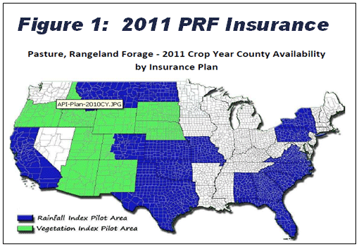
The September 30, 2010 sales closing date is rapidly approaching to enroll in the revised Pasture, Rangeland, Forage Risk Management Insurance program for policies in 2011. USDA’s Risk Management Agency (RMA) introduced the program in 2006 for the 2007 crop year. The program was recently revised and expanded. The same two separate basic provisions were retained, the Rainfall and the Vegetation Index Provisions, but the program was revised to a calendar year basis (Jan.-Dec.), participation sign-up deadline was changed to the end of September and selected coverage periods were extended to eleven overlapping monthly periods. While the program remains a pilot program, coverage was expanded to cover a large portion of the U.S. (see figure 1).
Policies are available through local crop insurance agents. Producers who have enrolled in this program will be automatically rolled-over into 2011, unless the producer cancels or changes the policy.
Other than the revisions mentioned above and other minor changes, such as participants must choose at least two of the eleven intervals, cannot have the same month twice and cannot have more than 50% of their insurable acreage in any interval, very little was changed with the fundamental mechanics of the insurance. Livestock producers may purchase insurance protection for grazing or perennial hay. Insurance programs are based on an index of vegetation greenness or on a rainfall index, depending on what state/region the producer is in. Only the rainfall index program is being offered in Texas, where the program was expanded to include all of the counties of the state.
Insurance Concept
Both the vegetation and the rainfall index programs are based on protecting the income potential of insured acreage. Producers are not required to insure all their acres. They may elect to insure only those acres that are important to their grazing program or hay operation and do not have to insure the acreage for the entire crop year. The crop year is a calendar year and is now divided into eleven two-month intervals, with overlapping months, i.e., (Jan-Feb), (Feb-Mar), (Mar-Dec), etc. The overlapping intervals were extended to insure better annual average of critical periods. Producers may elect to insure their acreage for only those intervals where the risk of the low normal rainfall is the greatest.
The rainfall index program measures losses based on the amount of rain received in a given interval, compared to a long-term rainfall index. The vegetation greenness program is based on satellite imagery that determines the greenness value of the range, helping to analyze range condition as a means to measure expected production losses.
Rainfall Index
The rainfall index program is for a single peril, lack of precipitation. The program covers potential losses of grazing and/or haying acreage. Producers are not required to insure all their acres. They may elect to insure only those acres that are important to their grazing program or hay operation. The crop year for the rainfall index program begins January 1 and is divided into eleven, two-month intervals with overlapping months. Producers may elect to insure their acreage for only those intervals where the risk of below normal rainfall is the greatest, but they must choose at least two of the eleven intervals, cannot have the same month twice and cannot have more than 50% of their insured acreage in any interval. The rainfall index program measures losses based on the amount of rain received as determined by the National Oceanic and Atmospheric Administration (NOAA) in a given interval and grid, compared to the historic average rainfall for the same interval and grid.
Each insurable county is divided into 0.25 degrees gridded area (approximate 12×12 mile area) established by NOAA and identified by longitude and latitude. Each grid is then assigned a rainfall index based on historical rainfall records (1948-2009) kept by NOAA. Each county within the pilot area has been assigned a protection value per acre i.e., the potential value per acre that normal rainfall could generate has been determined. For example, the protection value per grazing acre in Uvalde County is $8.25/acre. However, this value does not reflect an individual producer’s management of the land resources. To tailor this protection value, a producer may elect to adjust this value by choosing from 60% to 150% (in one percent intervals) of this value, based on his/her perception of the productivity of the plot being insured. In effect, the producer tailors the value to fit his own acreage management, such as past brush or weed control programs. Finally, like most insurance programs, producers must elect insurance coverage level of 70%-90% (in 5% intervals) of the posted rainfall index. For example, for Uvalde County with a 90% coverage level and productivity value of 150 percent selection, the protection level would be $11.14/acre.
The crop production year is divided into eleven, two-month intervals (Intervals: 1-Jan-Feb, 2-Feb-Mar, 3-Mar-Apr, 4-Apr-May, 5-May-Jun, 6-June-July, 7-Jul-Aug, 8-Aug-Sep, 9-Sep-Oct, 10-Oct-Nov, 11-Nov-Dec). Producers must select at least two, 2-month time periods in which precipitation is important for the growth and production of the forage species, e.g., April-May for spring and August-September for Fall. NOTE: For the Rainfall Index program in Texas, not more than 50% of the acres may be entered in any one of the intervals selected for insurance coverage and the sum of the acres by interval cannot exceed the total insurable acres.
Insurance indemnity payments to a producer are calculated based on the deficit from normal precipitation within the grid, index intervals selected and chosen coverage level.
A Recipe to Calculate Premiums and Coverage
While program details can be obtained and insurance policies purchased through local crop insurance agents, the following is a recipe for the use of an internet based decision aid tool to determine approximate premium costs and coverage:
1) Find your grid – Go to http://agforceusa.com/rma/ri/prf/maps Under the Rainfall Index, there are several ways to find your grid. Probably the easiest and fastest method is to type in the closest city to your ranch, in the top blank labeled “Find a Location” and click on search. NOTE: There is a menu of options and suggested steps on the left center menu which comes up. For the purpose of this example, type in Uvalde, TX and click Search. A map with Grid ID: 10921 will come up in this example.
2) Move the map left/right/up/down with the arrows on the upper left portion of the screen to locate your ranch. Increase/decrease scale with the gage on the left. For the purpose of this example, move the map on grid #10921, Uvalde and click at about the location of your ranch.
3) Click on Decision support tool under the Grid Tools menu on the left. NOTE: You can check the Historical Rainfall Indices, View Actuarial Info and View Cost Estimator from this menu.
4) A worksheet will come up. Fill out the blank spaces. Start by entering protection information on the top left menu. For example: Grazingland; Coverage Level, 90%; Protection Factor, 150%; Share, 100%; Insurable Acres, 1,000; and sample year, 2009. Click “Calculate” on the right lower corner of the screen. NOTE: A screen will display basic information, such as County Base Value per Acre, Dollar amount of protection per acre and other basic details.
To obtain an estimate of the cost/benefit relationship of insuring the 1,000 acres of grazingland in Uvalde, TX (grid# 10921) at 90% of the rainfall index and 150% of the productivity value factor for 2009, the number of Insured Acres per Index Interval must be entered. If, for example, if you want to check the insurance coverage consequence of insuring the 1,000 insurable acres over six equal intervals, E.g., 166.6 acres per period, you would enter 166.6 acres in each of period 1-(Jan-Feb); 3-(Mar-Apr); 5-(May-June); 7-(July-Aug); 9-(Sep-Oct) and 11-(Nov-Dec) and click on calculate on the lower right corner. NOTE: Since you cannot have the same month twice, the program skips intervals as you select the interval and enter the acreage.
The box on the bottom center of the screen that comes up provides a Summary of County Base Value per Acre, the Dollar Amount of protection per acre, Total Insured Acres, Total Policy Protection, the Subsidy Level and the Maximum % of Insured Acres per Index interval. The table provides a summary of each insured period. The column labeled Actual Index Value shows the percent of rainfall actually received in the selected year (2009 in this example) as it compares to the long term value. If less than 90% (the maximum coverage allowed) for a covered interval, an indemnity would have been paid. The last two lines provide a summary of the per acre and policy total for the selected year. In this example, the table shows a producer paid $1.52 per acre to protect potential income of up to $11.14 per acre. In 2009, the sample year selected, the policy would have paid $3,337 in indemnity payments ($4,859 indemnity less $1,522 premium).
For specific details and links to the various components of these programs go to:
http://www.rma.usda.gov/policies/pasturerangeforage./
Appreciation is expressed to Stan Bevers for his contribution to and review of this article.