AG-ECO NEWS
Vol. 24, Issue 31, October 21, 2008 – PDF version
Jose G. Peña
Texas AgriLife Extension Economist-Management
The Continuing Drought in Southwest Texas Will Make 2008 a Difficult Year for Agriculture And Require Special Planning for 2009
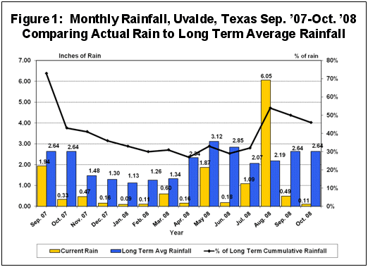
While parts of South Texas, especially the Lower Rio Grande region received excessive rains this summer, a large part of Texas remains in a severe drought. As measured in Uvalde, a large part of the southwest Texas region, which probably reflects the relative rainfall condition for a large portion of Texas, entered into drought conditions (75% of average annual rainfall) in September 2007 and has remained in severe drought conditions since then. The last 14-month period (September 1, 2007-to-October 21, 2008) with 13.6 inches of total cumulative rainfall, compared to a long term average of 29.45 inches for the same period, was the 3rd driest period on record behind the same period in 2006 with 9.61 inches and 1956 with 12.16 inches. Only 0.6 of an inch of rain has been received since September 1, 2008, compared to a long term average of 5.23 inches. (See Figure 1). 
Pastures, ranges and some crop land are in poor condition due to the extended dry period. The current drought is further aggravated as it comes closely behind the severe drought of 2005-’06. The recent cooler weather will help conserve moisture, but a large portion of Texas, especially southwest Texas is entering winter with less than 50% of the long term average rainfall of the last 14 months. The moisture situation is critical and will require special plans to cope with the continuing drought.
La Niña
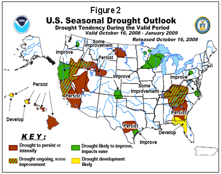
Unfortunately, the short-to-mid-term outlook for rain appears dim. Since June 2007, most of the U.S. experienced a La Niña event which strengthened in early 2008. Although neutral conditions (neutral between La Niña and El Niño) have been in place since June 2008, weather forecasts by the National Weather Service indicate that the atmospheric circulation over the western and central tropical Pacific continues to reflect lingering aspects of La Niña. El Niño and La Niña are terms referring to large-scale changes in sea-surface temperature across the eastern tropical Pacific. La Niña is the opposite of El Niño. El Niño features less storminess and milder-than-average conditions across the North and more rain across the southern tier compared to La Niña, which features less stormy conditions across the South and warmer than normal conditions across much of the southern tier. While La Niña is bringing too much rain during the harvest in the North Central U.S. corn belt region, it is bringing a severe drought to the southern tier. (See Figure 2).

Pastures and Ranges
Forage is in short supply. Even with minimum livestock stocking rates, the absence of forage and adequate stock tank water will have a serious effect on wildlife, which has become the economic lifeline for many ranching operations.
It will take years for pastures and ranges to recover from this drought, especially since it is close behind the severe drought of 2005-’06. Some may not recover without major range improvements.
