AG-ECO NEWS
Vol. 22, Issue 26, August 16, 2006
Jose G. Peña
Extension Economist-Management
Pasture, Rangeland, Forage Risk Management Insurance
Programs Available Starting in 2007
USDA announced recently that government subsidized Pasture, Rangeland and Forage risk management pilot insurance programs will be available starting in 2007. Policies will be available for sale, through local crop insurance agents, in late August or early September 2006, with a sales closing date of November 30, 2006. Subsidy rates vary by the amount of coverage purchased.
Livestock producers may purchase insurance protection for losses of forage produced for grazing or harvested for hay. The insurance programs are based on an index of vegetation greenness or on a rainfall index, depending on what state/region. Only the rainfall index program is being offered in Texas. (See Map, Figure 1).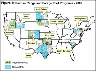
- Figure 1: Pasure Rainland Forage Pilot Programs – 2007
The rainfall index program will be tested in 220 counties in Colorado, Idaho, Pennsylvania, South Carolina, North Dakota and Texas. The vegetation greenness program index will be tested in 110 counties in Colorado, Oklahoma, Oregon, Pennsylvania, South Carolina and South Dakota.
Insurance Concept
Both the vegetation and the rainfall index programs are based on protecting the income potential of an insured plot. Producers are not required to insure all their acres. They may elect to insure only those acres that are important to their grazing program or hay operation and do not have to insure the acreage for the entire crop year. The crop year is divided into two-month intervals. Producers may elect to insure their acreage for only those intervals where the risk of the low normal rainfall is the greatest.
The rainfall index program measures losses based on the amount of rain received in a given interval, compared of a pre-determined rainfall index. The vegetation greenness program is based on satellite imagery that determines the greenness value of the range, helping to analyze range condition as a means to measure expected production losses.
Rainfall Index
The rainfall index program is for a single peril, lack of precipitation. The program covers potential losses of grazing and/or haying. The Rainfall Index is based on National Oceanic and Atmospheric Administration (NOAA) rainfall data, which has been compiled and indexed to 12×12 mile square grids. In other words, each insurable county is divided into 12×12 mile grids and assigned a rainfall index based on historical rainfall records (1948-2005) kept by NOAA. Then a county productivity value per acre i.e., the potential income per acre that the rainfall could generate, has been determined for each county. For example, the productivity value per acre in Uvalde County is $8.21/acre. Producers can elect to adjust this productivity by choosing from 60% to 150% of this value based on his/her perception of the productivity of the plot being insured. Finally producers would elect insurance protection of 70%-90% (in 5% intervals) of the posted rainfall index.
The production year is divided into six 2-month intervals (Intervals: I-Feb-Mar, II-Apr-May, III-June-July, IV-Aug-Sep, V-Oct-Nov, VI-Dec-Jan). Producers must select at least two, 2-month time periods in which precipitation is important for the growth and production of the forage species, e.g., April-May for spring and August-September for Fall. These time periods are called index intervals. NOTE: For the Rainfall Index program in Texas, not more than 50% or less than 10% of the acres you want to protect with insurance may be entered in any one of the intervals selected and the sum of the acres by interval cannot exceed the total insurable acres.
Insurance payments to a producer suffering from abnormal rainfall are calculated based on the deficit from normal precipitation within the grid and index interval(s) selected.
A Recipe to Calculate Premiums and Coverage
While program details can be obtained and insurance policies purchased through local crop insurance agents, the following is a recipe for the use of an internet based decision aid tool to determine approximate premium costs and coverage:
1) Find your 12×12 mile grid – Go to: http://prfri-rma-map.tamu.edu/default.aspx (NOTE: the initial grids shown are around Bryan, TX where the program was developed). There are several ways to find your grid. Probably the easiest and fastest method is to type in the closest city to your ranch, in the left center of the screen under “Type a city name and click find.” For the purpose of this example, type in Uvalde and click Find. Confirm the city if more than one option appears.
2) Move the map left/right/up/down with the arrows on the borders of the map to locate your ranch.
3) Center the grid which includes your ranch. For the purpose of this example, center map on grid #39645, Uvalde.
4) Click on item #2, Decision support tool under “View data of this location”, on the lower left corner of the screen. NOTE: You can check the Historical rainfall indices for this site by clicking on item #3
5) A worksheet will come up after clicking on item #2. Fill out the blank spaces and click on Submit Query on the lower right corner.
NOTE: The program allows a user to check the amount of an indemnity (if paid) for each of the 58 years from 1948 to 2005. For the purpose of this example, select 2005 as the sample year.
Table 1 provides a summary of the cost/benefit relationship of insuring 100 acres of grazingland in Uvalde, TX (grid# 39,645) at 90% of the rainfall index and 140% of the productivity value factor, with 50 acres in Index Interval II (Apr-May) and 50 acres in Index Interval IV (Aug-Sep). Please note that 2005 was selected as the sample year to see if an indemnity would have been paid. After submitting the Query, the upper right hand box provides a Summary of County Base Value per Acre, the Dollar Amount of protection per acre and other details. The last two lines of table 1 show the per acre and the total policy values. So, it would cost a producer $0.97 per acre to protect potential income of up to $10.34 per acre. In 2005, the sample year selected, the policy would have paid $2.73/acre.